
|
Discover your city
Whether you are a citizen or city authority, make smarter transport choices by understanding how each road, train or subway is moving.
|
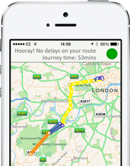
A 'living' journey planner that knows your cityThe Catch! journey planner can give better, frustration free routing because the community automatically shares live travel conditions on all methods of transport.
|
|
|
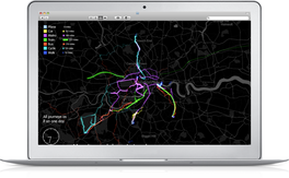
Manage your city with 20/20 visionCatch! gives cities rich detail on how their transport systems are operating so they can evaluate pinch points, identify trends and make informed decisions.
|
Register to get Catch! in your city |
|
How it works
Built for your city - The journey planner is tailored for the city’s available transport modes and allows citizens to enter places by name as well as the usual options, so they could enter ‘City Hall’ instead of having to look up the address first.
Adaptive route planning - In addition to route planning based on data from leading timetable and roadwork information, Catch! also feeds in live data of how the transport system is operating and being used to provide even more accurate and useful routing suggestions.
Innovative crowdsourcing technology - The live data is automatically generated by the citizens themselves. The mobile app boasts technology that automatically detects route, mode of transport and journey duration without requiring any input from citizens.
Data by the people for the people - The anonymised community data feeds back into the journey planner to improve results and is available to cities and transport operators to help improve transport services.
Want to know more? - Please see our FAQs or contact us.
Banner image: © Copyright Colin Smith and licensed for reuse under this Creative Commons Licence
Google Play and the Google Play logo are trademarks of Google Inc.
